Sombrero
Sombrero 2025
My sons, Teryn and Corey, and I went to Sombrero
with the Anguilla National Trust
on September 13, 2025.
- Took Pictures with phones (Vince and Teryn).
- Did Google Street view of Sombrero both on foot (Corey and Vince) and by drone (Teryn) (click on blue circles or blue lines to see images).
- Made a video flying around with drone (Teryn).
- Video of Friendly lizards at Sombrero Island it nearly went extinct
- Tried out a Starlink Mini and it worked fine.
The camera in 1997 was my first digital camera and only held about 15 low resolution pictures.
The total storage was uner 1.2 MB.
Today cell phones hold thousands of high resolution pictures.
We had a starlink mini. We had a drone.
We had Insta 360 camera for streetview.
The tech for capturing images has improved a lot in the last 28 years.
The next section of this page is the same as it was in 1997.
Sombrero 1997
On May 1st, 1997 I (Vince) took a boat trip out to Sombrero. This
island is part of Anguilla (owned by the government) and is 40 miles
North-West of the main island of Anguilla.
The boat just pulls up near a metal ladder that has been lowered
down into the water. You climb up the ladder and then there
are stairs.


The island is about 3/4 mile long and 400 yards wide at
the widest point. Much of the ground is big rocks,
so hiking around the island is a bit slow.
The light house is the main feature on the island.


There are no coral reefs or sandy beaches, the waves come right
up to the rock. During hurricanes the waves blow right over the
island. In Hurricane Luis the stove, refrigerator, etc
were all washed out of the building near the base of the light house.


There are many many birds on Sombrero. It is hard to show how many
with pictures. The birds were very approachable. This is not a
zoom lens or anything, in the last shot I am about 10 feet from the
closest bird.


I went up to the top of the light house and took a couple
pictures from up there. The view of Sombrero is, of course,
is very good.


The men who operate the tower say that on most days
they can see St Martin, and frequently they can even see Saba.
However, Anguilla is very low and so not usually visible.
The boat ride was about 1
hour and 45 minutes each way,
and we spent about that long on the island.
It was a fun trip.
Sombrero History
- The round base was for the original metal tower shipped from London.
This became operational on Jan 1, 1868.
- The stone tower was erected in 1893. Was 51 feet tall. It was damaged by Hurricane Donna in 1960.
- The red tower on the square base was the active tower when I was there in 1997.
This was built in 1962.
- The current tower became operational in 2001. Can see pictures of people in it and from it in 2025 street view photos.
This history is from an AI but seems reasonable. :-)
Other Sombrero Pages
- wikipedia on Sombrero lighthouse
- wikipedia on Sombrero Island
- Anguilla Archaelogical and Historical Society.
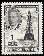
This has a picture of a stamp that shows the original tower on the round base.
Vince Cate